Posts

Showing posts from 2017

New Caledonia and on to Australia

Image
It was an easy 2 1/2 day sail to New Caledonia from Vanuatu, and it turns out that our charts are very accurate here (that’s often a question when arriving in a new country). Although New Caledonia has many beautiful islands and reefs, we were here for Malcolm to see the cardiologist so we anchored in the main harbour in the capital city of Noumea. We made an appointment and found the cardiologist to be a really nice guy from France who now lives here. He explained there is a new procedure that can be done which usually prevents atrial fibrillation, but we’d have to go to Australia or Canada to get it done. We spent a bunch of our time in Noumea looking for where to put the boat for cyclone season, looking for flights to Vancouver, and so on. When we weren’t doing those things we did explore the town, which has several great places to get delicious food (French and tropical) and strong coffee! Meeting the owner of a great cafe in Noumea Our friends on Roxanne were also

Leaving Vanuatu

Image
Our plan was to continue north to the Torres island group, an even more remote part of Vanuatu, and then sail on to the Solomon Islands. Sailing plans have to be flexible. Somewhere along the way, Malcolm got a bug bite on his leg that got infected and wasn’t really responding to the medication we had on board. Our friends, Chuck and Laurie on Free Spirit, had met up with us in Ureparapara and they both had cuts or bites that were not responding to medication. Perhaps the medication had expired, but we didn’t know. What we were sure of was that we were 2-3 days from medical assistance and going to an even more remote place was a bad idea. Free Spirit was already planning on heading south, and we decided that heading back to “civilization” was a good idea, so both boats left Ureparapara and sailed south. Woman walking to her garden to collect food Waterfall on Sola The weather was a bit rough, but not unreasonable, so three days later we were anchored in the northern end

Ureparapara

Image
Torba province is pretty remote and does not get many visitors. Of the few yachts that do come this far north, very few go past Sola, that motivated us to go further north. The next stop after Sola is the island of Ureparapara. The island was formed by an ancient volcano, and the north east portion is “missing” so the crater is actually a large bay. Satellite image of Ureparapara It took most of the day to sail from the northern edge of Vanua Lava to Ureparapara. It was somewhat surreal pulling into the bay, surrounded on three sides by steep jungle-covered walls rising out of what used to be the volcano crater. The only spot to anchor is just off the village at the end of the bay. The village is typical, perhaps a bit prettier than most. Everyone we met was very friendly and curious about us. The village chief told us that about 5 yachts visit every year. There are probably about 150 people living on the island, and nobody has any electricity other than an old car/boat bat

Sola

Image
After two days of rest in Lusalava, Gaua, and as the stinging and aches subsided after Dina’s failed waterfall hike, we sailed about 4 hours to Sola, on Vanua Lava. Sola is the capital of the northernmost province of Vanuatu, Torba Province, consisting of the Banks and the Torres Islands. Ashore we found a small variety of stores and a “Yacht Club” that was also a guesthouse. The "Yacht Club" The locals were friendly and assured us that the saltwater crocodiles were further north and rarely ventured out of the river. These crocodiles were said to have either been introduced in the last century by Bishop Patterson – although it is unclear what purpose the Bishop thought the crocodiles could serve to the people of Vanua Lava – or there is belief the crocodiles swam to Vanuatu from the Solomon Islands after getting lost during a cyclone. We were told there was a weekly Friday market, the next day, and we saw flyers about a school fundraiser that included food, dancing an

Lost in the jungle

Image
We anchored next in Lusalava, on the north side of the island of Gaua. We had been told that from this bay there was an easy walk to a stunning waterfall. Visiting onshore, Dina asked many locals and everyone agreed the waterfall was an easy 2-hour walk. So the next day at 9 AM, Dina and Chuck, from SV Free Spirit, set off for a leisurely walk to a reportedly stunning waterfall. As they walked through the village, people pointed them in the direction of the walk, all saying the waterfall is easy to reach. Dina asked a few people about an informal guide, perhaps a young person who could accompany them. On the outskirts of the main village, a man suggested his son and friend, Eric and Sos, both around 19 years old, could show them the way. Soon Chuck and Dina were following these kind young men through fairly rough forest. They had turned off the main road and seemed to be following an animal trail. Soon they were in a thick jungle. After stopping to drink fresh coconut milk, t

Gaua - start of the Banks Group of Island

Image
Our next destination was the Banks Group of islands. This group is even more isolated than the rest of Vanuatu, partially due to the extra distance. The southernmost island, Gaua, is 25nm north of Espiritu Santo. This is too far for most of the locals, and most cruisers don’t bother making the crossing so they turn south after Espiritu Santo. In order to arrive at Gaua before dark, we made a 05:30 departure from Port Orly on the northern end of Espiritu Santo. The forecast was supposed to be a downwind sail, but it turned out to be 3 hours of motoring, then 6 hours of sailing upwind. Most of the 6 hours was spent hand steering because the little CPT Auto-pilot didn’t deal well with the big swells. It just cannot anticipate as well as we can. Our friends on Free Spirit were about 1 hour behind us the whole way. We anchored in Lacona on the SW side of Gaua, where there is a lovely black sand beach we’d have to explore the next day. The morning mist looked lovely in the jungle green m

Back on Espiritu Santo

Image
Without much wind, we motor-sailed back west to Oyster Bay, back on Espiritu Santo Island, about 20km north of Luganville. The entrance to Oyster Bay is quite tricky. With some waypoints from “Mr. John” and Malcolm on the bow, Dina made it in, manoeuvring around shallow coral heads, without touching! During the days we were there, other boats were not as lucky. From Oyster Bay, we dinghied up the river to the Matevulu Blue Hole. It is a nice freshwater blue hole surrounded by banyan trees and grazing cows. The local land owners have added a ladder to the large banyan tree and a rope swing. Although the Oyster Bay Resort was closed for renovations by the new Chinese owners (Chinese have purchased quite a bit of property in Santo and own many businesses), the Turtle Bay Resort was open. With Lynn and Tom from SV Roxanne, we rented a small car from the resort and drove north to the Loru Conservation Area. While this is described as a bird sanctuary, it was really a nice trek throug

Million Dollar Point, Millennium Cave and Ansanvari

Image
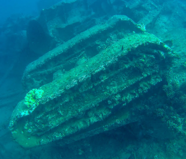
American Forces were stationed on Espiritu Santo during WWII, and after the war they tried to sell their equipment to the French, who administered Vanuatu (or New Hebrides as it was known). The French knew it would be very expensive for the Americans to ship everything home, so they didn’t want to buy anything, hoping instead that the Americans would just leave things behind. However, the Americans didn’t like this idea, so they dumped everything into the sea. The story is that over $1 million dollars’ worth of trucks, jeeps, cranes, and other equipment was dumped off of what is now known as Million Dollar Point, just east of Luganville. Much of this equipment is in fairly shallow water so we went and snorkelled it. The wind was up, so there was a lot of silt in the water, but it was still very interesting to see the old “junk”. Upside down tank? Crane? Truck Jeep After several days, we motored back to Luganville did a very large provisioning. Fortunately, the LCM groc